Why Localised Asset Creation Is the Secret to Scaling Across UK Zoning and Design Standards
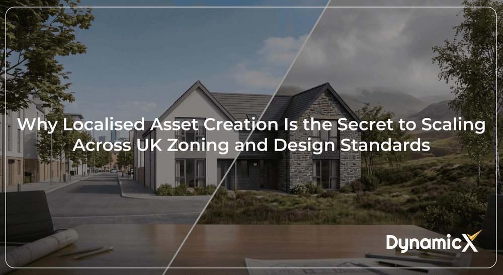
Here's the main idea in one line: the same building design needs to be shown in different ways depending on which part of the UK you're building in.
The 3D model itself can stay mostly the same. But the patterns, the methods, and the visual style used to present it to planners have to change from region to region. That's the whole point of this article.
Why one prototype isn't enough
A developer might design one strong building and want to use it again and again across the country. That sounds efficient. But the UK doesn't have one planning system it has four, one for each nation, and each one looks at design differently.
A design that gets approved quickly in England might get stuck for months when it's shown to a council in Scotland, Wales, or Northern Ireland. This isn't because the building itself is wrong. It's because it was shown the wrong way for that place.
This is where a visualisation studio adds real value: turning one design into many locally believable versions, without rebuilding the whole model from scratch every time.
The four planning systems, in plain terms
England
Rules are set out in the NPPF, alongside the National Model Design Code. Planners want to see how a building fits the street and the local area's character.
Scotland
Rules are set out in NPF4, working together with each local council's own plan. Scottish planners care a lot about how a design fits the wider landscape, especially in rural and Highland areas.
Wales
Rules come from Planning Policy Wales and Future Wales, supported by the Design Commission for Wales. Welsh planners look closely at local materials like Welsh slate and stone and how a design fits National Parks and coastal areas.
Northern Ireland
Planning decisions are mostly made by local district councils, guided by the Strategic Planning Policy Statement. Because local plans are still being finished in some areas, older planning rules are still used in the meantime, so expectations can vary even within Northern Ireland.
Every one of these systems is really asking the same question in a different way: does this building belong here, and can you show me that it does?
What changes, and what stays the same
The core of the 3D model the shape of the building, the floor layout, the structure can usually stay the same everywhere. That part doesn't need to be redone.
What does need to change for each place:
Materials - roof tiles, wall finishes, and textures that look right for that specific region
Landscaping - plants, trees, and surroundings that match the local environment
Setting - how the building sits against local hills, skylines, or nearby streets, especially in protected areas like National Parks
Presentation style - some planning authorities expect very realistic, camera-accurate images (called Accurate Visual Representations or Verified View Montages), while others focus more on how a building fits the wider landscape
If a studio sends the exact same, unchanged image to a council in the Scottish Highlands, a council in Cardiff, and a council in Belfast, all three will feel like they're looking at a design made for somewhere else. That's the problem localised visuals solve.
Four ways localised visuals help
1. They speak the local design language
Changing materials and finishes to match each area's design code shows a planner that the building has genuinely been designed with their area in mind not just dropped in from elsewhere.
2. They prove the design respects the landscape
Using real survey data lets a studio show accurately how a building sits among hills, trees, and skylines especially important in National Parks or other protected areas.
3. They help win over local communities
Most planning systems now put more weight on what local residents think before an application is even submitted. Clear, realistic, locally-styled images are much easier for ordinary people to understand and support than technical drawings.
4. They meet each council's expected visual standard
More and more UK planning authorities expect precise, camera-matched images rather than rough sketches. Meeting this expectation properly, in the style each authority is used to, makes an application easier to approve.
How to manage this without starting over each time
A simple way to think about it:
Part | What it includes | How often it changes |
Core model (~80%) | The building's shape, layout, and structure | Built once, reused everywhere |
Local details (~20%) | Materials, landscaping, setting, and presentation style | Redone for each region to match what that area expects |
The skill is in getting that second, smaller part right every time not just changing the colours, but genuinely adapting the materials, setting, and presentation style to match what each planning authority is used to seeing.
The bottom line
A developer building across England, Scotland, Wales, and Northern Ireland isn't dealing with one set of rules four times over they're dealing with four different ways of judging design. A visualisation approach built around one solid core model, with the local details properly redone each time, makes this manageable: fewer delays, fewer rejections, and a design that looks like it truly belongs wherever it's shown.
Planning to build across different parts of the UK? Get in touch to see how a localised 3D visualisation approach can help your design get approved faster, wherever it's headed.